Bengaluru Traffic Police Deploy Drones at High Density Junctions
Bengaluru traffic police are using drone surveillance at busy junctions to understand congestion quickly and support traffic management during morning and evening peak hours across the city.

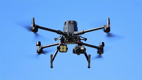
Bengaluru Traffic Police are expanding the use of drone surveillance to keep a closer watch on congestion at some of the citys busiest junctions. The aerial view is expected to help officers understand traffic movement more clearly and respond faster when problems develop.
The drone monitoring is being carried out mainly during morning and evening peak hours, when traffic volumes rise sharply across the city. Ten traffic subdivisions have been provided with a drone each for monitoring road conditions and congestion.
The system is particularly useful at locations where traffic builds up across multiple levels of a road or junction. Aerial footage can give officers a broader picture than observations made from ground level. Bengaluru Traffic Police have previously used drone cameras at congested locations for this purpose.
Hebbal, Town Hall and Silk Board are among the important locations where drone based monitoring is being used. These areas regularly handle large volumes of vehicles and can experience sudden congestion following accidents, vehicle breakdowns or changes in traffic movement.

The drones can provide live visuals from above, allowing traffic personnel to see how vehicles are moving through different sections of a junction. This can help officers identify where queues are forming and decide where traffic management measures may be required.
The technology can also be useful when traffic conditions change within a short period. A minor incident at a busy junction can quickly create long queues, particularly during peak hours. Having an aerial view gives traffic personnel additional information while dealing with such situations.
Bengaluru Traffic Police have been using technology for traffic monitoring in several ways. Their systems include digital tools used by field officers to report incidents such as accidents, road blockages, flooding and traffic congestion. Drone footage adds another layer of information by giving officers a wider view of the road network.
Joint Commissioner of Police Traffic Karthik Reddy has also highlighted the role of technology and traffic management measures in dealing with congestion and road safety. Recent traffic restrictions on selected flyovers were also explained by Reddy as measures linked to road design, accident management, congestion and emergency traffic handling.
Drone surveillance can be particularly helpful during special traffic situations. The police can use aerial information to monitor important routes when large movements of vehicles are expected, including routes affected by VIP movement.
For commuters, the main expectation is that the additional monitoring will help officers spot congestion before it spreads across nearby roads. Faster identification of blocked lanes or unusual traffic movement could allow personnel on the ground to respond without waiting for complaints from motorists.
The use of drones is not intended to replace traffic officers on the roads. Ground personnel are still required to control signals, manage diversions and respond to incidents. The drone provides an additional view that can support those decisions.
The technology has already been used in Bengaluru to monitor several congested locations. Earlier deployments included areas such as Hebbal, Central Silk Board, Ibballur, Marathahalli and KR Puram, demonstrating the usefulness of aerial monitoring in locations where congestion can develop across different road levels.
With Bengaluru continuing to face heavy traffic volumes, authorities are looking at a combination of technology, traffic restrictions and infrastructure changes. Recent discussions around major junctions such as Hebbal have also focused on finding ways to manage severe congestion through different transport and road measures.
For now, the drone programme gives traffic police another way to observe the citys busiest roads. The effectiveness of the system will depend on how quickly aerial information is converted into action by officers managing traffic at ground level.
As the monitoring expands, commuters may see drones operating above some major junctions during the busiest parts of the day. The aim is straightforward: get a clearer picture of where traffic is building up and help the police respond before congestion becomes harder to control.